 Mrs.
Cirino - Social Studies Unit- 4th Grade
Mrs.
Cirino - Social Studies Unit- 4th Grade Mrs.
Cirino - Social Studies Unit- 4th Grade
Lesson Title: Where in the World? Understanding Latitude and Longitude
Subject Area(s): Social Science, Geography, Technology
Lesson Summary:
This lesson teaches students how to use longitude and latitude to locate various cities, regions, landforms, and bodies of water around the globe. Students use The New York Times Learning Network’s crossword puzzle “Longitude and Latitude” to sharpen their atlas skills.
Learning Objectives:
By the end of this lesson, the students will:
§ Familiarize themselves with the different maps, information, and tools founding an atlas.
§ Understand how latitude, longitude, minutes and seconds are used, and determine locations using latitude and longitude measurements.
§ Apply knowledge of latitude and longitude to a crossword puzzle in which they must use atlases to answer clues comprised of latitude and longitude coordinates.
California Academic Content Standards:
§ Social Science
· 4.1 Students demonstrate an understanding of the physical and human geographic features that define places and regions in California.
1. Explain and use the coordinate grid system of latitude and longitude to determine the absolute locations of places in California and on Earth.
2. Distinguish between the North and South Poles, the equator and the prime meridian; the tropics; and the hemispheres, using coordinates to plot locations.
3. Identify the state capital and describe the various regions of California, including how their characteristics and physical environments (e.g., water, landforms, vegetation, climate) affect human activity.
4. Identify the locations of the Pacific Ocean, rivers, valleys, and mountain passes and explain their effects on the growth of towns.
5. Use maps, charts, and pictures to describe how communities in California vary in land use, vegetation, wildlife, climate, population density, architecture, services, and transportation.
§ Technology
· 1.0 Basic operations and concepts
o Students demonstrate a sound understanding of the nature and operation of technology systems.
o Students are proficient in the use of technology.
Materials:
|
§ Latitude and Longitude Tutorial: § http://www.nytimes.com/learning/students/xwords/may_cross_tut.html |
§ Copies of The Learning Network’s “Latitude and Longitude” Crossword Puzzle: § http://www.nytimes.com/learning/students/xwords/may99_image.html |
|
§ Computers with Internet Access |
§ Crossword Puzzle Answer Grid |
|
§ Individual and Team Think Sheets |
§ Assessment Rubrics |
|
§ Website “Hot Sheet” |
§ |
|
§ |
§ |
Vocabulary:
1. longitude:
§
longitude,
angular distance on the earth's surface measured along any latitude line such
as the equator east or west of the prime meridian. A meridian of longitude
is an imaginary line on the earth's surface from pole to pole; two opposite
meridians form a great circle dividing the earth into two hemispheres. By international
agreement, the meridian passing through the original site of the Royal Greenwich
Observatory at Greenwich, England, is designated the prime meridian, and
all points along it are at 0 longitude. All other points
on the earth have longitudes ranging from 0 to 180 E or from 0 to 180 W. Except
where it is changed to account for populated areas, the international date
line lies along the 180 meridian. Meridians of longitude
and parallels of latitude together form a grid by which any position
on the earth's surface can be specified. The term longitude
is also used in various celestial coordinate systems (see ecliptic coordinate
system).
© 2002 Columbia University Press (Information retrieved from BigChalk.com)
2. latitude:
World Book Encyclopedia (2002) 01-01-2002
LAT uh tood Latitude,
describes the position of a point on the earth's surface in relation to the equator. Latitude is one of the two grid coordinates that can be used to locate any point on the earth. The other coordinate is longitude.
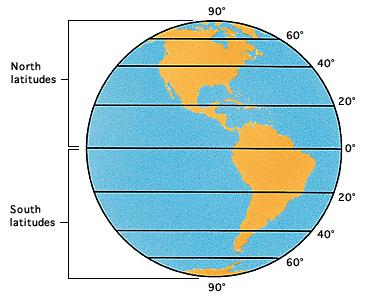
Latitude
Imagine a series of lines running around the earth parallel to the equator,
shown here. These are lines of latitude. Every point
on the earth's surface lies on such a line. It shows the position of that spot
in relation to the equator.
World Book Encyclopedia illustration by Sarah Woodward
The latitude of a point is measured in terms of its distance from the equator toward one of the earth's poles. Latitude is measured in degrees. Any point on the equator has a latitude of zero degrees (written 0 ). The North Pole has a latitude of 90 north and the South Pole has a latitude of 90 south. These two points are sometimes written +90 and -90 . Degrees of latitude are divided into 60 minutes ('), and the minutes each consist of 60 seconds (").
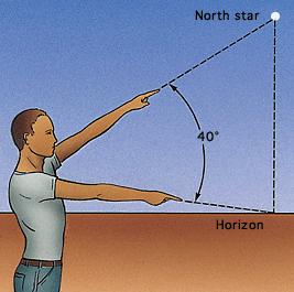
How to estimate latitude
A way to estimate latitude is to point one arm at the
North Star and the other at the horizon. The number of degrees of the angle
between your arms is about the latitude where you are.
World Book Encyclopedia illustration by Sarah Woodward
All points on the earth's surface that have the same latitude lie on an imaginary circle called a parallel of latitude. The distance between two parallels that are 1 apart is about 60 nautical (sea or air) miles, or 69 statute (land) miles or 111 kilometers. This length of 1 of latitude varies from 59.7 nautical miles near the equator to 60.3 nautical miles near the poles. The variation results because the earth is not a perfect sphere. A difference in latitude of 1 minute equals about 1 nautical mile.
See also Climate - The role of latitude; ; Equator; ; Longitude; ; Map; .
© 2002 World Book, Inc. and its licensors. All rights reserved. "World
Book" and the globe device are trademarks of World Book, Inc.
3. atlas:
Atlas
is usually a book of maps. It often includes facts and figures about places. The term atlas may also be used for volumes that present a subject in an illustrated or tabular form. A geographical atlas usually contains maps, charts, and tables. Maps may show cities, towns, roads, countries, rivers, mountains, the size and relationships of land and water areas, and the names of features and places. An index lists the names of such features and tells where to find them on the maps. Maps may also show the distribution of economic resources, population, types of climate, and plant life.
Standard atlases in the United States include Hammond's New World Atlas, Goode's World Atlas, and the Rand McNally Cosmopolitan World Atlas. The Rand McNally Commercial Atlas and Marketing Guide includes sales distribution maps, postal information, lists of national parks and monuments, and other valuable facts. Examples of large world atlases with relatively detailed maps are the Times Atlas of the World, the Touring Club Italiano Atlas, in Italian, and the Russian Atlas Mira. Several countries publish national atlases with maps showing physical, economic, and cultural resources. For example, the National Atlas of the United States is published by the U.S. Geological Survey.
In the A.D. 100's, Ptolemy, a geographer who lived in Egypt, published what most historians consider the first atlas. This was part of his Geography, an eight-volume work on mapmaking. Gerardus Mercator, a Flemish cartographer, first used the name atlas for a collection of maps in the late 1500's. Mercator may have used this name because an earlier collection of maps had on its title page an illustration of the Greek god Atlas supporting the earth on his shoulders.
Early cartographers drew the maps in their atlases by hand. The production of atlases increased with the invention of printing. Notable among the early atlases is Theatrum Orbis Terrarum, published in 1570 by Abraham Ortelius of Antwerp.
See also Map ; .
© 2002 World Book, Inc. and its licensors. All rights reserved. "World
Book" and the globe device are trademarks of World Book, Inc.
4. equator:
Equator
is the great circle of the earth that lies halfway between the North and South poles. This imaginary line divides the earth into two equal parts called the Northern Hemisphere and the Southern Hemisphere. It is the starting point for the degrees of latitude that measure distances north and south from the equator to the poles (see Latitude; ). The latitude of the equator is zero. On a globe, the equator is also a line on which equal distances are marked to show degrees of longitude, which measures east and west distances (see Longitude; ). The circumference of the earth at the equator is 24,901.55 miles (40,075.16 kilometers). Each degree of longitude at the equator equals 69.17 miles (111.32 kilometers).
The location of the equator can be determined by observing the elevation of the North Star or the sun above the horizon. Allowing for slight corrections, the angle of elevation of the North Star at any given place equals the latitude of that place. Thus, at the equator, the North Star is barely visible above the horizon and has an elevation of nearly zero degrees.
The equatorial climate.
The climate along the equator varies according to altitude and the distance from the sea. In most equatorial lowlands, heavy rains and average temperatures are uniform all year. But the east coast of Africa has only light rain and a long dry season. Quito, Ecuador, which lies almost exactly on the equator, has an elevation of 9,350 feet (2,850 meters). It has a uniform temperature that is about 25 Fahrenheit degrees (14 Celsius degrees) cooler than nearby lowlands.
The celestial equator
is an imaginary circle that goes around the sphere in which the earth and heavenly bodies lie. It helps locate stars and planets. See Astronomy - Locating objects in space; .
The magnetic equator
is the line on which all points are equally distant from the north and south magnetic poles. See Magnetic equator.;
© 2002 World Book, Inc. and its licensors. All rights reserved. "World
Book" and the globe device are trademarks of World Book, Inc.
5. prime meridian:
§
prime meridian prime meridia,
meridian that is designated
zero degree (0 ) longitude, from which all other longitudes are measured. By
international convention, it passes through the original site of the Royal Observatory
in Greenwich, England; for this reason, it is sometimes called the Greenwich
meridian. Universal time, the standard
basis for determining time throughout the world, is civil time measured
at the prime meridian.
© 2002 Columbia University Press
Teacher Lesson Plan:
Divide students into pairs and give each pair an atlas. In the first five minutes of the period, ask students to flip through their atlases and list the answers to the following on a piece of paper (written on the board prior to the period):
§ What different types of maps are found in the atlas?
§ What other information on countries and locations is provided in the atlas?
§ What tools does the atlas provide so that you can quickly find a location?
Students then share their answers, familiarizing themselves with the features of an atlas and ways in which atlases can be used.
Distribute “Latitude and Longitude Tutorial” to each student and review it as a class. Then, allow students a few minutes to use their atlases to answer the questions on the worksheet in pairs or individually. Students should compare answers as a group and suggest different ways in which they found the answers to the questions.
Distribute The New York Times Learning Network’s “Latitude and Longitude” crossword puzzle. Thirty of the puzzle clues ask students to use an atlas to find a location given its latitude and longitude. You may want to circle these clues on the puzzle before copying it for the class or I can write them on the board for easy student reference:
“Across” Clues: 1, 9, 13, 14, 16, 18, 23, 32, 33, 44, 47, 49, 51, 59, 62, 67
“Down” Clues: 2, 5, 10, 15, 17, 24, 28, 29, 43, 51, 53, 55, 56, 61
Allow students time to use their atlases to find the answers to the clues that use latitude and longitude. As names of locations in atlases may vary, encourage students to use other atlases to answer difficult questions.
Students work in small groups to finish the thirty longitude and latitude questions on the crossword puzzle.
When everyone is done, the answers can then be reviewed and discussed.
Extension Activities:
§ What different types of maps have you seen?
§ What different types of maps can be found in an atlas and what are their purposes?
§ How do world maps, globes and atlases serve different purposes?
§ Why might latitude and longitude have been developed?
§ What types of people do you think use latitude and longitude in their daily lives and why?
§ What is the relationship of latitude and longitude to the study of geography?
§ Why are understanding how to use atlases and how to use latitude and longitude measurements important skills?
Results Presentation
Students will be evaluated based on their ability to use an atlas to find locations around the world given longitude, latitude and minute measurements.
Culminating Activity:
Our first culminating activity will have students create their own crossword puzzles in small groups that contain the words: North and South Poles, equator, prime meridian, the tropics, and hemispheres.
The next activity will be to create a map of California that identifies the following characteristics:
§ The state capital
§ Descriptions of the various regions of California, including how their characteristics and physical environments (e.g., water, landforms, vegetation, climate) affect human activity.
§ Descriptions of how communities in California vary in land use, vegetation, wildlife, climate, population density, architecture, services, and transportation.
(This lesson plan was originally written by Annissa Hambouz, The New York Times Learning Network and Javaid Khan, The Bank Street College of Education in New York City. It was modified and adapted for use in a 4th grade classroom by Cynthia Cirino, New Haven Unified School District, Union City, California. The NTeQ lesson plan template was modified from its original version, which can be found on the NTeQ website at: http://www.nteq.com/ )
The New York Times – Longitude and Latitude Tutorial
Look on almost any map or globe and you will see lines going vertically and
horizontally, forming what looks like a grid over the Earth's surface. These
lines, called latitude and longitude, assign numbers to every location on the
map. The unit of measurement for latitude and longitude is called a degree,
which is indicated by a small circle to the upper left after a latitude or longitude
is given (ex. 60°).
Latitude, the lines that run left to right on a map or globe, is always listed first when assigning a measurement. The equator is found at 0° latitude, and there are 90 degrees to each of the poles. The N or S following a latitude measurement indicate whether the degrees are measured north or south of the equator.
Longitude, the lines that run up and down on a map or globe, is always listed second when assigning a measurement. The prime meridian is found at 0° longitude, and there are 180° going both east and west from the prime meridian to the International Date Line. The E or the W following a longitude measurement indicate whether the degrees are measured east or west of the prime meridian.
Minutes and seconds sometimes follow latitude and longitude measurements to more accurately pinpoint a location. Each degree can be divided into sixty minutes, usually indicated by a single quotation mark (ex. 5') or by numbers following a period in the latitude or longitude measurement. For example, 90°15'N could also be written as 90.15N. Each minute can be divided into sixty seconds, indicated by a regular (double) quotation mark (ex. 5'').
You can use a map or globe to find general latitude and longitude measurements, or an atlas, which is a collection of maps, for more specific measurements including minutes and seconds. Practice using an atlas to find the following locations (be sure to include degree signs and direction):
What can be found at 90° N? ____________________
What can be found at 90° S? ____________________
What city in England is located at longitude 0°?____________________
What city in the United States is located at 40° N, 75° W? ____________________
What other cities are located at latitude 40° N? ____________________
What other cities are located at longitude 75° W? ____________________
Find your city on a map or atlas. At what latitude and longitude are you right now? ____________________
Find your country on a map or atlas. What is the approximate range of latitudes and longitudes that your country covers? ____________________
There are many online atlases and geography resources available if you don't have an atlas. Visit some of these sites, and see what they have to offer:
Earth Viewer (http://www.fourmilab.ch/earthview/vlatlon.html) allows you to view either a map of the Earth showing the day and night regions at this moment, or to view the Earth from the Sun; the Moon; the night side of the Earth; above any location on the planet specified by latitude, longitude and altitude; from a satellite in Earth orbit; or above various cities around the globe. The site is produced by Fourmilab of Switzerland.
Map Machine Atlas (http://www.nationalgeographic.com/resources/ngo/maps/) includes political and physical maps, flags, facts, and country profiles; from National Geographic.
Atlapedia Online (http://www.atlapedia.com/) contains full color physical and political maps as well as key facts and statistics on countries of the world.